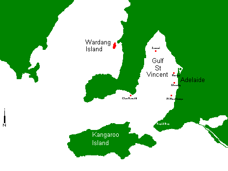
| Dive Site | Depth | Latitude | Longitude |
|---|---|---|---|
| Zanoni | 18m | 34-30.817 S | 138-03.725 E |
| Norma | 16m | 34-49.657 S | 138-25.031 E |
| Songvaar | 8m | 34-27.705 S | 137-23.159 E |
| Clan Ranald | 23m | 35-09.975 S | 137-37.329 E |
| Broken Bottom | 11m | 34-57.701 S | 138-28.923 E |
| Saurian | 29m | 35-06.984 S | 138-24.548 E |
| Sth Australian | 21m | 34-58.753 S | 138-26.548 E |
| H A Lumb | 20m | 35-08.968 S | 138-26.418 E |
| Glenelg Tyres | 21m | 34-58.992 S | 138-26.575 E |
| Grange Tyres | 20m | 34-54.028 S | 138-23.992 E |
| Noarlunga Tyres | 20m | 35-08.915 S | 138-26.457 E |
| Pt Giles Tyres | 15m | 35-02.800 S | 137-47.400 E |
| Rapid Bay | 10m | ||
| Kangaroo Island | |||
| New site |
Submitted by Garry Douglas - Sat 05 Oct 1996
Depth: 18m Vis: Average to poor
Description:
The Zanoni was a 3 masted composite barque which topped up her load
of wheat and bark at Pt. Wakefield. On Monday 11th Feb 1867, she left for
Adelaide before beginning the long journey to England. It was a beautiful
February morning with a light easterly blowing. In the afternoon a squall
appeared in the west and the order to lower the sails was given. Before
this order could be carried out, the squall hit. The vessel was thrown
on her beam ends and then turned turtle in a matter of minutes. Fortunately
no lives were lost.
At 11 o'clock that night the crew were rescued and taken to Pt. Adelaide.
Attempts to locate the wreck the following day was fruitless. She remained
a mystery of the deep until 17 Apr 1983 when Rex Tyrrell took divers to
examine a reef he regularly fished. The reef was the ZANONI. The Zanoni
is protected under the Historical Shipwrecks Act and a permit must be obtained
for all persons wishing to dive on the wreck.
For more information contact the:
The Department of Environment & Natural Resources
GPO Box 1047
ADELAIDE SA 5001
Ph. (08) 8204 9478
Submitted by Garry Douglas - Sat 05 Oct 1996
Depth: 16m Vis: Average
Description:
The Norma was a four masted iron barque 278ft long. On 21st April 1907,
the Norma was at anchor in the Semaphore anchorage when another vessel,
the Ardencraig, approached with the intention of anchoring nearby. The
Marine Board of Inquiry was told that due to the poor visibility, the light
of the Norma was mistaken for that of the Pilot. When it was realized it
was in fact the Norma, evasive action did not avert a collision. One life
was lost.
The following morning another ship, the Jesse Darling, ran over the
sunken Norma and it too was sunk. After the Jesse Darling was re floated
it was decided the Norma was a shipping hazard and it was levelled with
explosives on two occasions. Thus now the wreck is no more than 3m above
the sea bed and spread over a wide area. It will take more than one dive
to see the Norma.
The Norma is covered by the Historic Shipwrecks Act so no parts may
be removed.
Submitted by Garry Douglas - Sat 05 Oct 1996
Depth: 23m Vis: Excellent
Description:
The ship was 355ft long and was built in 1900 as a two-deck turret
ship for the Clan Line. While the ship was being loaded at the Semaphore
Anchorage, it was sitting on the bottom at low tide, so the small list
to starboard was not noticed. On 31st January 1909 while en route to Africa
and only hours out of Pt Adelaide, she rounded Troubridge Point into Investigator
Strait at 2.00pm. These waters between the mainland and Kangaroo Island
can be very treacherous. A large wave caused the Clan Ranald to lurch 45
degrees to starboard. The crew panicked and ran to the deck leaving the
motors running and the rudder out of the water. Later in the afternoon
a strong wind blew from the south east and forced the ship onto rocks near
Troubridge Hill. Thirty six lives were lost and their graves may be found
in Edithburgh. Twenty of the Twenty four survivors were deported as illegal
Filipino and Indian immigrants.
The vessel lies on it's side in 23m of water with the boiler 5m from
the bottom. There is still much of the wreck to be seen. The Clan Ranald
is protected by the Historic Shipwrecks Act, so no items are to be removed.
Air fills are available in Edithburgh.
Submitted by Garry Douglas - Sat 12 Oct 1996
Depth: 11m Vis: Usually good
Description:
Along the Adelaide coastline are a large number of limestone reefs
and the Broken Bottom is another section. This is a large area of rocky
outcrops and sand gutters just teeming with our usual variety of reef fish.
These vary from the iridescent and shy Blue Devils to the common leather-jackets
which sometimes have to be shooed away like flies. Looking closely, a sting-ray
may be seen buried in the sand with just his eyes showing. With the variety
and vastness of this site, many dives are possible without seeing the same
area twice.
Submitted by Garry Douglas - Sat 12 Oct 1996
Depth: 29m Vis: Average
Description:
The Saurian is the largest of three barges deliberately scuttled 5km
west of Port Stanvac. This was done by the Department of Marine and Harbors
on 24 November 1954. They form an artificial reef and attract a large variety
of fish. The Saurian, formerly a dredge, was a coal lighter when it's useful
life ended. It is 163ft long and 30ft wide. Two smaller barges 71ft by
49ft also lay in 30m of water 100-130m north east. Due to the depth of
these barges, bottom time is very limited and more than one dive is needed
to explore these wrecks. This dive should only be done by advanced or
deep divers.
Submitted by Garry Douglas - Sat 05 Oct 1996
Depth: 21m Vis: Usually good
Description:
The best wreck dive in Adelaide is the South Australian. Commonly known
as The Dredge , it was formerly a suction dredge owned and operated by
the Department of Marine and Harbors. It was sunk by the Department in
1985 to form an artificial reef 6km from the seaside suburb of Glenelg.
It is 133ft long and sits upright on a sandy bottom. The wheel house is
at 12m. It is possible to penetrate the wreck and see some of the pipes
and tubes needed to operate it. This should only be done with a buddy
experienced in this site. The wonders of this place is the thousands
of bullseyes which open like a curtain to let you swim through as well
as the resident wobegong.
Submitted by Garry Douglas - Sat 05 Oct 1996
Depth: 20m Vis: Usually good
Description:
The H A Lumb, before coming to Adelaide, was a prawn trawler working
out of Port Lincoln on the Sth Australia's Eyre Peninsula. It was purchased
by the combined effort of all the dive stores in Adelaide and the help
of scuba divers. After being stripped and made safe for divers as well
as for the environment, the 90ft long H A Lumb met it's watery grave in
December of 1994. Situated about 3km from Pt Noarlunga jetty it lies in
20m of water, and sits upright with the deck at 15m. Due to the efforts
by the workers in removing the superstructure, it is a safe dive for the
relatively inexperienced. Over the time it has been down, I have seen more
and more marine growth on the hull, with fish also finding out where they
can live in comfort.
Submitted by Garry Douglas - Sat 05 Oct 1996
Depth: 20m Vis: Varies
Description:
Modules of used car tyres were tied together to form a tetrahedron
with the sides four tyres wide. Many of these modules were placed in various
location around the state to form an artificial reef. They are home to
many variety if fish and plants. I have also seen common and leafy sea-dragons
on the Pt Noarlunga site. If you do see a Leafy Sea Dragon please make
a note of where and when and pass this information to a local dive shop
or club who will pass it on to the research group. The Leafy Sea Dragon
is a TOTALLY protected marine species.
Locally known is "The Bay", Glenelg is one of Adelaide's most popular
beaches. It is situated near the mouth of the Patawalonga 12Km south west
of Adelaide. It is on this site the state of South Australia was founded
in 1836.
On the south side of the "Pat" is the sailing club, while further south
is the main shopping area. On the north side of the "Pat" is the boat ramp
which is the starting point for our boat dives. From here we can reach
The South Australian which is located very close
to a hopper barge and tyre reef. On the left as we leave the boat ramp
there are the remains of a break-water known as The Blocks, while further
out to our right is the Broken Bottom
Port Noarlunga is situated on the mouth of the Onkaparinga River some
25Km south of Adelaide. From a bustling port earlier this century, it is
now a mecca for beach goers and divers alike. This is without doubt the
most popular shore dive site in Australia due to it's closeness and shelter.
The jetty now only extends to a limestone reef about 200m from shore. Once
the reef is reached, a diver may head north or turn south and follow a
marked dive trail. Cairns are placed at irregular intervals with a description
of the immediate area and what may be seen.There is generally a very light
long-shore current from south to north inside the reef. Most divers in
Adelaide had their first open-water experience under the Pt. Noarlunga
jetty. Really keen divers are able to climb over the reef. It is a marine
reserve, so the only thing you may take from the water is memories and
photos.
About 5km north of Pt Noarlunga is the O'Sullivans Beach boat ramp.
From here, we leave to explore such sites as the dump, the
barges a tyre reef and our latest wreck HA Lumb.
Further south along the coast are the Aldinga Reefs, also a marine reserve
and excellent area to dive.
Further along the coast, and requiring the use of a boat, is Rapid Head. Rapid Head is a cliff entering the water to a depth of 10m and all along are small & large rocks and limestone bommies. As well as teeming with fish life, the area is also home to many types of colourful soft corals and sponges. The shy and very vivid Blue Devil may be seen hiding in the many crevices, which may also be home to an octopus. Access may be obtained from the boat ramp at Paradise Wirrina Cove Marina or currently from Cape Jervis.
Depth: 10m
Description:
South Australia is fortunate to have an abundance of terrific jetty
diving. St. Vincent gulf, and beyond, are scaped with a variety of small
and large jetties, all offering something unique to themselves. Wool Bay,
a site often overlooked has its own resident school of Old Wives and a
prolific amount of sea horses hiding in the surrounding sea-grass. Pt.
Noarlunga is home to a myriad of sedentary life and Nudibranchs abound
at Wallaroo. Each one of these jetties puts forth its own worth and all
require further investigation and continuous future dives to glimpse even
a portion of their secrets.
One jetty among all stands alone - Rapid Bay. This particular site is overwhelming, even after many years it never ceases to amaze; gin clear water is usually the case and although surge is sometimes present it is never threatening. A sandy bottom, underneath most of the jetty, surrounded by lush green sea-grass is proof of a healthy environment. Situated on the north western coast of the Fleurieu Peninsula, Rapid Bay is the most southerly accessible jetty dive within easy reach of metro Adelaide. It sources life from the wild and tumultuous Southern Ocean and everything and anything can show up there.
During the cooler months, copious quantities of Leafy Sea dragons ( Phycodures eques) can be found on the seaward side of the T-section and many are of impressive size. As you swim towards the centre you soon realise what makes Rapid Bay special the amount of fish life is awesome. Everywhere you look you are bombarded by countless varieties of marine life, some stand out immediately while others meld slowly in to complete the big picture. Large schools of Pike, Tommy Ruff and Yellowtail are always present, continuously moving about between one another on endless sojourns.
Perhaps the most attractive species at Rapid Bay would be the Old Wives, they are so profuse that they literally take command over the entire T-section. It seems that the other fish have given them this respect - maybe it is their home of many years and their friends are only visitors - they hover motionless behind every pylon and keep constant watch on your every move and seem to occupy a character all of their own. Ornate cowfish, Shaws cowfish, Pipefish, Magpie perch, Gurnards and even the Short finned Conger Eel have taken up resiliency, among many other varieties which seem to flourish under the towering canopy of Rapid Bay.
There are many different dives to be done under and around Rapid Bay jetty. You may enter at the end and work your way back to shore, providing conditions are right. ( it must be calm as it can be hazardous climbing among slippery rocks in less than favourable conditions) This is a complete change of scenery, almost hike a different site altogether. You can also work your way to the southern end, tie on a reel, and go for a wander over the sea-grass beds (Yellowtail Kingfish have been seen before ) or you can try a night dive and really see it going off.
Not only a perfect jetty dive but Rapid Bay is also a great place to go camping for the weekend. Green grass, skirted with tall pines, and clear shadow water make it a perfect swimming beach for divers and their families and Second Valley is just around the corner - a great double dive. So, consider your next dive and go south for not just any jetty dive but for an outstanding adventure.
Nick Piekarski.
Haystacks & the Althorpe Islands are situated in Investigator Straight between Yorke Peninsula and Kangaroo Island. Access is generally from Marion Bay, which also has air fills.Overnight accommodation is available here or at nearby Stenhouse Bay which is part of the Innes National Park. The southern part of Yorke Peninsula is also well known for it's surf, and many surfies spend their time here. It is a rugged coastline as it faces the full swells from the Southern Ocean. The area also boasts some of the best diving and fishing in Sth Australia. During Christmas and Easter holidays accommodation is at a premium with divers, anglers and surfers. Sometimes I think the boat ramp needs traffic lights.
Around the islands the water is generally clearer than in Gulf St Vincent, and with a current up to 4 knots, a very enjoyable drift dive is possible.
Depth: 15m Vis: Usually Good
Description: Boat dive out of American River with Kangaroo Island Diving Safaris, preceded by a white-knuckle ride through and down the countryside. The boat ride to the site allowed a stop to swim and play with friendly dolphins. The area consists of rocky bottom just offshore, covered with algae. Interesting topography lots of islets and cracks with crays and abalone. Curious Sea Lions observed our dives. Squadrons of Old Wives greeted us. We also saw Port Jackson shark, several leatherjackets, sizeable Blue Devils, one friendly and several distant Blue Groper wrasse. The jewels in the crown were Leafy Sea Dragons on every dive, Weedies on some. One Leafy was distinctly in berry. We've dived worldwide, and will be back- even though it's over 12,000 km away. Kangaroo Island itself has many things to do for the non-diver or resting diver, from nature walks to night drives.
This your opportunity to tell us about your favourite boat dive.
Please note: Although it is most unlikely that you will experience any
problems responding to this form, certain non-standard browsers will not
respond properly.
If you experience any difficulties, (or if you are not using a forms-capable
browser) you may email your response to this form to: bwc@iweb.net.au.
Copyright © 1997
Go to: [Index]- [Blue Water Charter]- [Scuba Info]- [Dive Sites]- [Dive Calendar]